Maribyrnong Flood History: Maps, Local Impacts and Information for Residents
Maribyrnong flood history: maps, local impacts and information for residents, from 1906 to 2022, with clear steps to check your home's flood risk and get ready.
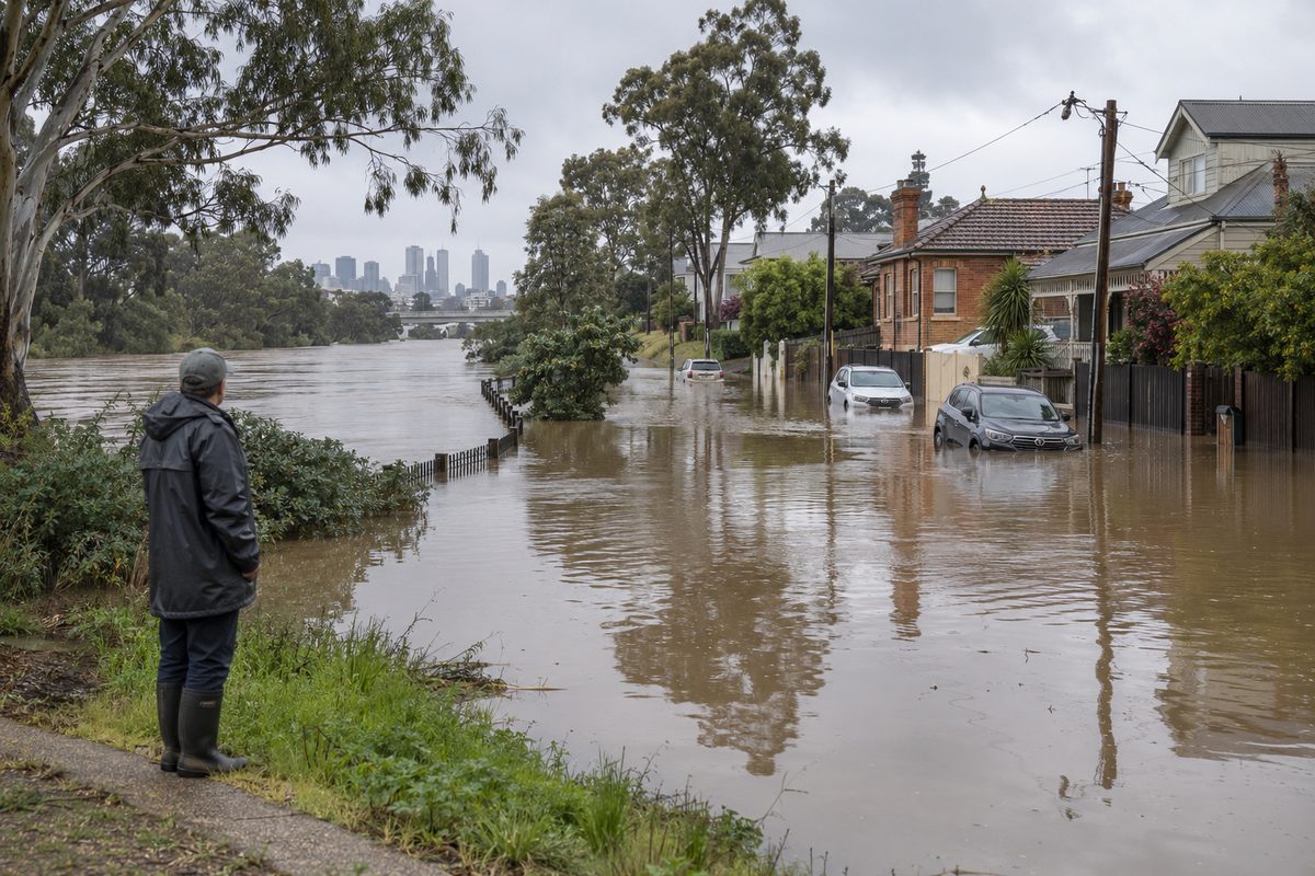
The Maribyrnong River has flooded many times, and the worst events, in 1906, 1974 and 2022, reached homes and businesses that sat on the low land beside the water. The pattern is simple. Heavy rain falls on the upper catchment, the river fills fast, and the flat ground in the lower valley takes the water. If you live, rent or work near the river, this history tells you what has happened before and what could happen again.
This guide covers the major floods, how to read the flood maps, what the damage looked like for locals, and what to do now. It skips the wider story of the suburb, which is covered in our piece on how Maribyrnong grew from industry to riverside neighbourhoods.
Why does the Maribyrnong River flood at all?
The Maribyrnong River collects water from a large area north-west of Melbourne. Its upper reaches start in the Macedon Ranges, where steep, wet country sheds rain quickly. That water runs south through farmland, then reaches the wide, flat valley at Keilor, Victoria. From there the river bends through Avondale Heights and the inner west before meeting the Yarra River near the docks.
That shape matters. The upper catchment is steep and fast. The lower valley is flat and narrow in places, with houses, roads and parks built close to the banks. When a big storm hits the ranges, the flood wave travels down the valley and spreads out over land that has no room to hold it.
The tide adds a second problem near the mouth. The river meets the Yarra, and the Yarra flows out into the bay near Williamstown, Victoria. If a high tide or storm surge arrives at the same time as a flood, the water cannot drain away as quickly. I have heard long-time locals say the worst nights are the ones when everything lines up.
What were the major floods in Maribyrnong's past?
The record goes back well before modern gauges. The floods people still talk about are these:
- 1906: One of the largest on record. Water covered large parts of the low-lying river flats and cut off crossings in the days before modern levees and drainage.
- 1916: Another large event that reminded early settlers how far the water could spread.
- 1974: The flood that shaped living memory. Thousands of people across Victoria were affected that October, and the Maribyrnong valley was hit hard, with many homes and businesses inundated.
- 2011 and 2022: Two modern events. The October 2022 flood was the biggest in decades and reached a level many residents had never seen.
I know this part well because one of my clients, a woman who had lived near the river since the 1970s, told me she measured every flood against 1974. When the water rose in 2022, she did not wait for a warning to feel sure. She moved her car and her photo albums upstairs the same afternoon. She said, "I knew what the sky looked like." That kind of local memory is worth listening to, but it is not enough on its own. Memory fades, and new residents do not have it.
What happened in the October 2022 flood?
Heavy rain fell over already wet ground in early October 2022. The river rose quickly and reached levels not seen since the 1970s in some places. Water entered homes in Maribyrnong and Avondale Heights, and streets near the river became impassable. Many residents were told to leave. Some had very little time.
The people I spoke with afterwards described the same few problems. The water came faster than they expected. Mobile phone alerts arrived late for some and not at all for others. Roads they would normally use to leave were already under water. A man I know who lived a few streets back from the bank told me he thought he was safe because he was not on the river itself. His garage still took water through the stormwater drains, which backed up when the river rose.
That detail is one most articles miss. You do not need to be beside the river to be hit. Flooding can come through drains, low streets and gaps in the landscape that you would never notice on a sunny day.
How does flood management work along the river?
Flood management here is shared. Melbourne Water looks after the river, its drains and the flood studies that decide where the risk is highest. Local councils handle planning rules, local drainage and road closures. The Victoria State Emergency Service responds to flooding, helps with evacuation and sandbagging, and runs public warnings with other agencies.
Engineering plays a part too. Levees, retarding basins and upstream storage can slow or hold back some of the water. The Maribyrnong valley has works of this kind, but they have limits. A structure built for one size of flood does not protect you from a larger one. In 2022 the flood overtopped or bypassed defences in places, which is why planners now talk about residual risk, meaning the risk that remains even when protection exists.
Emergency management in Victoria follows a plan that covers preparation, response and recovery. For residents, the practical point is that agencies can warn you and help you, but they cannot be at every door. Your own plan is the part you control.
How do you read a Maribyrnong flood map?
A flood map shows how far water is expected to spread in a flood of a certain size. Most maps use probabilities, such as a flood with a 1 percent chance of happening in any year. People often call that a 1-in-100-year flood. The name misleads. It does not mean once every hundred years. It means a 1 percent chance each year, which adds up over the length of a mortgage.
Here is how to use the maps well:
- Find your exact address, not just your suburb. Risk can change from one street to the next.
- Look at the flood extent and the depth, if shown. A property can be wet in the yard but dry inside, or the reverse.
- Check the access roads. A dry house is no use if every road out is flooded.
- Check the date of the map. Newer studies use better data and often change the lines.
Melbourne Water publishes flood information for properties, and you can request a flood level report for a specific address. Councils also hold planning overlays that mark land subject to inundation. I always tell clients to get both, because they answer different questions. One tells you how deep the water might be. The other tells you what building rules apply.
One warning from experience. A client of mine bought a unit after checking only the council overlay, which showed nothing alarming. The deeper flood report, which she requested later, showed the car park below the building would go under in a major flood. She still bought it, but she planned for it, and she moved her car to higher ground during the 2022 event. Knowing early gave her options.
Which areas have felt the impact most?
The suburbs closest to the river carry the most risk. In the lower valley that includes Maribyrnong itself, where houses, parks and some commercial land sit near the water. Further upstream, Avondale Heights has streets that reach the river flats, and Keilor has older homes and recreation land in the valley. Flat land near bends in the river tends to flood first and flood deepest.
The impacts reach beyond houses. Sporting grounds and walking tracks are often closed for weeks. Businesses lose stock and trading days. Roads and bridges are cut, which splits communities in two. Train services can also be disrupted when flooding affects the network, so it is worth knowing your transport options. If you rely on the Sunbury line, for example, the Keilor Plains railway station is one point on that corridor you can check for service updates before you try to travel in a storm.
The cost is not only physical. People who lived through 2022 told me about months of cleaning, drying and waiting for repairs. Some moved out for a long stretch. Others said the hardest part was the worry every time heavy rain was forecast. That stress is real and it is part of the local impact, even though no map shows it.
How do flood warnings work, and where should you check?
The Bureau of Meteorology issues rain forecasts and official flood watches and warnings for Victorian rivers, including the Maribyrnong. Those warnings give predicted river heights at gauges along the river. The Victoria State Emergency Service passes on safety advice and, in serious events, issues emergency alerts to phones and other channels.
A flood warning is only useful if you see it in time. In my experience the people who coped best did three things at once, which I will split in two sets so they are easy to act on. First, they checked the Bureau of Meteorology warnings and the VICSES updates when heavy rain was forecast, rather than waiting for a knock on the door. Second, they watched what the river was doing for themselves and spoke to neighbours.
Do not rely on a single source. Phone alerts can lag. Websites can be slow when everyone is checking them at once. A battery radio is old fashioned and it still works when the power goes out.
What does flood damage mean for insurance?
Insurance is where many residents get caught out. Not every home policy covers flood the same way. Some policies cover storm damage but treat river flooding differently, and the wording changes between insurers. Since 2012, Australian insurers have used a standard definition of flood for home policies, but you still need to confirm that your policy includes it and what the limits are.
A client of mine learned this the hard way. She had paid her premiums for years and assumed she was covered. When she read the product disclosure statement after the 2022 flood, she found a clause she had never noticed. She was lucky, because her insurer paid. Others in her street were not so sure and spent weeks sorting it out.
Do these checks before the next storm season:
- Read the flood section of your policy and note any exclusions.
- Ask your insurer whether your address has a flood loading or a flood exclusion.
- Check your contents cover separately. Landlords insure the building, not your belongings.
- Photograph your home and valuables now, and store the photos online.
Renters should pay special attention. Your landlord's policy will not replace your furniture, clothes or electronics. Contents insurance with flood cover is cheap compared with what you could lose.
What should you do before the next flood?
Preparation does not take long. I tell people to do the work on a dry weekend, not on the night.
- Check your risk. Request a flood report for your address from Melbourne Water and read your council overlay.
- Write a plan. Decide where you will go, which route you will take and when you will leave. Include pets.
- Pack a bag. Keep documents, medication, chargers, a torch and some cash in one place you can grab in minutes.
- Know your high ground. Work out where to move your car and what you can lift off the floor.
- Sign up for alerts. Follow the Bureau of Meteorology and VICSES, and tell your neighbours how you get your warnings.
- Fix your insurance. Confirm flood cover in writing.
During a flood, never walk or drive through floodwater. It hides debris, holes and strong currents, and it is often contaminated. If the SES tells you to leave, leave early. A house can be repaired. You cannot.
What do most articles on this topic get wrong?
Most flood write-ups treat the river as the only danger. In practice, the drains, the low streets and the roads out of the area cause as much trouble as the river itself. Many also treat a past flood as the upper limit. It is not. The 1974 flood was serious, and a bigger one is still possible.
Another mistake is assuming new owners can rely on old stories. I have met buyers who were told, "It never floods here," by a seller who simply had not been there in 1974 or 2022. The map and the report are better sources than a conversation over a fence.
What is the one thing to do this week?
Request a flood report for your address from Melbourne Water, then check that your insurance covers river flood in writing. Those two steps take less than an hour, and they turn the long history of the Maribyrnong River from a vague worry into a clear plan you can act on.